Seamlessly navigate through every stage of the mining life cycle with the power of advanced machine learning models and geospatial intelligence. Keep a streamlined flow of valuable insights at your disposal, under your control.
Effortlessly create custom-built machine learning models to extract the information you need from your data. Whether it's detecting cracks and erosion in mining sites, monitoring water bodies throughout the mine site, or tracking rehabilitation efforts, Picterra empowers you to effortlessly set up, maintain, deploy, and reuse these models.
We go beyond just providing a platform. Our team of experts offers professional services to accelerate your time to production and maximize your return on investment. From training models for specific areas of interest to addressing your unique requirements, we are committed to ensuring your success.
With Picterra, you can create a scalable system to operate geospatial machine learning models in production and continuously develop them, catering to diverse mining use cases. Lead the way with powerful platform features and capabilities.

Easily work with any geospatial imagery type, format, and resolution to perform comprehensive data analysis. Whether it's optical, thermal, or radar imagery, digital elevation models, multi-spectral or hyperspectral data, or even sub-centimeter image resolution, Picterra enables you to handle it all with ease.
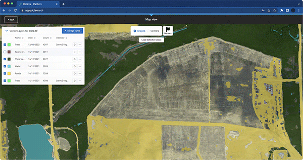
Picterra offers a comprehensive suite of innovative tools to curate your data, analyze model performance, and refine your models for optimal results. With these cutting-edge tools at your disposal, take your models to new heights of accuracy and quality.
Picterra seamlessly integrates into your established workflows, maximizing the value of your mining data. Our API enables you to automate a wide range of tasks, from uploading georeferenced images from local or remote servers, importing object annotations or detection areas, exporting detection results into other software, or embedding them into customized dashboards.
Deforestation monitoring
Efficiently monitor and report the impact of mining on forests. Detect and map deforested areas over time using satellite imagery, ensuring compliance with environmental regulations.
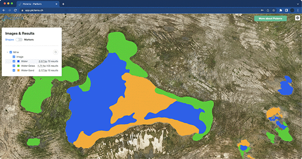
Water bodies detection
Detect and map water bodies across mining sites for safety and environmental purposes. Leverage drone imagery and machine learning models to automate the identification of different types of water bodies.
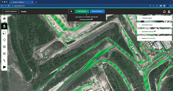
In-pit haul roads mapping
Ensure efficient emergency access, response, and safety within mining sites. Detect and accurately map in-pit haul roads using satellite imagery, enabling effective road maintenance and analysis.
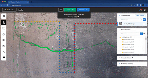
Cracks and erosion detection
Monitor geological features around mining sites for early detection of cracks and erosion risks. Utilize drone imagery and machine learning models to enhance safety assessments and minimize structural dangers.
Land mapping and classification
Prepare for mine site rehabilitation by accurately mapping and classifying the land. Employ drone imagery and machine learning models to detect various land features, facilitating effective rehabilitation planning and progress monitoring.
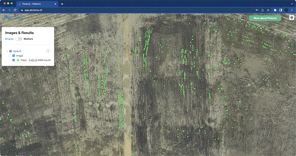
Re-vegetation monitoring
Track the progress of re-vegetation efforts and detect changes in the biodiversity-ecosystem. Analyze drone imagery using machine learning models to monitor the growth of small trees and ensure compliance with rehabilitation requirements.
Digital asset management
Optimize asset management practices by leveraging geospatial AI analytics. Detect well pads, pump jacks, and other assets using satellite imagery, enabling efficient site status surveys, record updates, and asset configuration comparisons.